Geographic Information Systems have become powerful tools that are able to resolve complex problems of planning and management. The main utility is related with the capacity to build models or representations of the real world from spatial data.
CESGA has extensive experience working with these tools since 1994, developing diverse projects related with GIS technology, including those related with information concerning patrimony, the environment ,or transportation, and participates and supports research initiatives of the sector in the Galician community.
GIS services provided by the Galician Supercomputing Center
The CESGA’s map server creates and provides dynamic maps developed in projects. These maps allow the user maximum interaction with geographical information, accessing information in its original format so that it is possible to search as you would with a GIS.
A map server works by sending maps at user’s request of the user from his or her browser as a page with an associated map in image format. A map server is a GIS through Internet. In addition to viewing the maps, one can interact with them with operations such as zoom, pan zoom, selective search, or to look up information on associated databases.
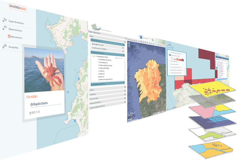
DIVERSIMAR Project
|
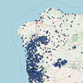
Asian hornet (Vespa velutina) distribution monitoring map
|
PHENOLOGIT Project
|
iSEAS Project
|
Estrimnides Project (Northwest of Iberia route of Estrimnides, Intercultural Mediterranean Trade)
|
PROPSOLOS Project
|
IDEPATRI Project
|


 Design and development of a data model for a Iron Age archaeological Spatial Data Infrastructure in Northwest Spain.
CESGA offers its users the opportunity to develop a specific map server with its own alphanumeric data for the purpose of Internet services or on an intranet.
GIS technologies offer a variety of interoperable and easily integrated alternatives that are accessible to the entire organisation, from desktop applications to services offered via the web. CESGA has extensive experience in developing customised solutions in the production of complete applications that manage data processing as well as the programming of GIS utilities and applications.
CESGA also offers the possibility of developing Web applications specific to the user, equipped with a set of visualization tools and a geo-referenced data editing service that allows offering dynamic maps on the Internet. In addition, it offers applications with custom solutions to meet the management needs of not only data and tools, but also to structure information in an orderly manner.
Participation in RTD in the field of geographic information systems involves developments based on Open Geospatial Consortium standards and the application of spatial data infrastructure
This Service provides processing techniques, automatic classification, and graphic representation of content. The common goal is to indicate the places of interest and the topics contained around which various elements are grouped and to display or visualise them on a GIS.
Any digital mapping project requires the integration of cartographic information from various sources. Because geographic information is organized as layers of data, it is possible to measure, consult, model, and conduct other analyses that take advantage of data from many different disciplines. Population data, for example, can be analysed in conjunction with industrial data, and, thereby, development maps can be elaborated. This ability to link data from different sources is possible due to the integration of different data layers. If they do not integrate with each other, no spatial analysis of any type can be conducted.
CESGA offers its users the possibility to develop a custom map server with its own alphanumeric data and to offer them in Internet or an Intranet.
Geographic Information Systems have revolutionized the way to access and analyze geographic information.